- Period
- 2021–2024
- Location
- Vales Region, Rio Grande do Sul, Brazil (case studies: Sobradinho, Rio Pardo and Encantado)
- Partners
- Mikripoli research network on small cities
- My role
- Network member: statistical and spatial data analysis, typologies, comparative case studies, maps and co-authoring; also teaching and workshops.
- Data
- IBGE REGIC (1966–2018) · IBGE censuses (2010, 2022) · DEE-RS · RAIS and CAGED · Landsat imagery · Google Earth · OpenStreetMap · Municipal data · Fieldwork
- Tools & methods
- QGIS · Statistical analysis · Typology building · Morphological analysis
The challenge#
Small cities are the majority of urban centers in Rio Grande do Sul, but urban research and planning tools are designed for large cities. Many small municipalities were created by successive emancipations and have little technical capacity. As part of the Mikripoli research network, I worked on describing them with data rather than assumptions.
Approach#
The work moved between three scales: the regional network over time, a typology of small cities, and the urban form of individual towns.
- Network over time
Regions of influence of cities, 1966 to 2018 (IBGE REGIC)
- Typology
Small cities grouped by population, economy, services and centrality (IBGE, DEE-RS)
- Morphology
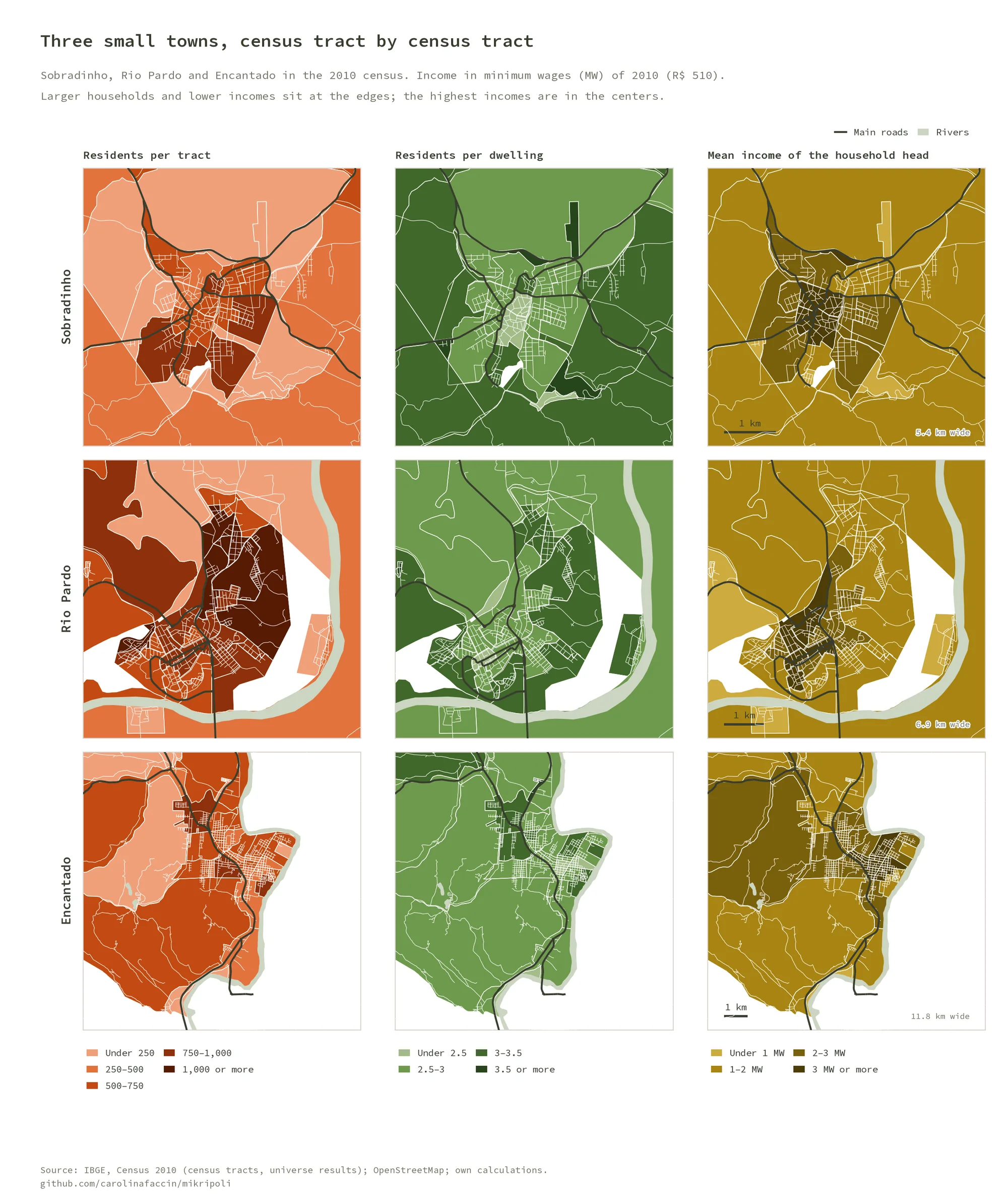
Census tracts, satellite imagery and fieldwork in three towns
- Synthesis
Inputs for planning adapted to small cities
Results#
- Small cities form most of the regional network, providing basic services locally, while Santa Cruz do Sul and Lajeado gained centrality through public management and specialized services, supported by tobacco and poultry/pork agro-industry.
- A typology of small cities based on how they take part in the regional division of labor.
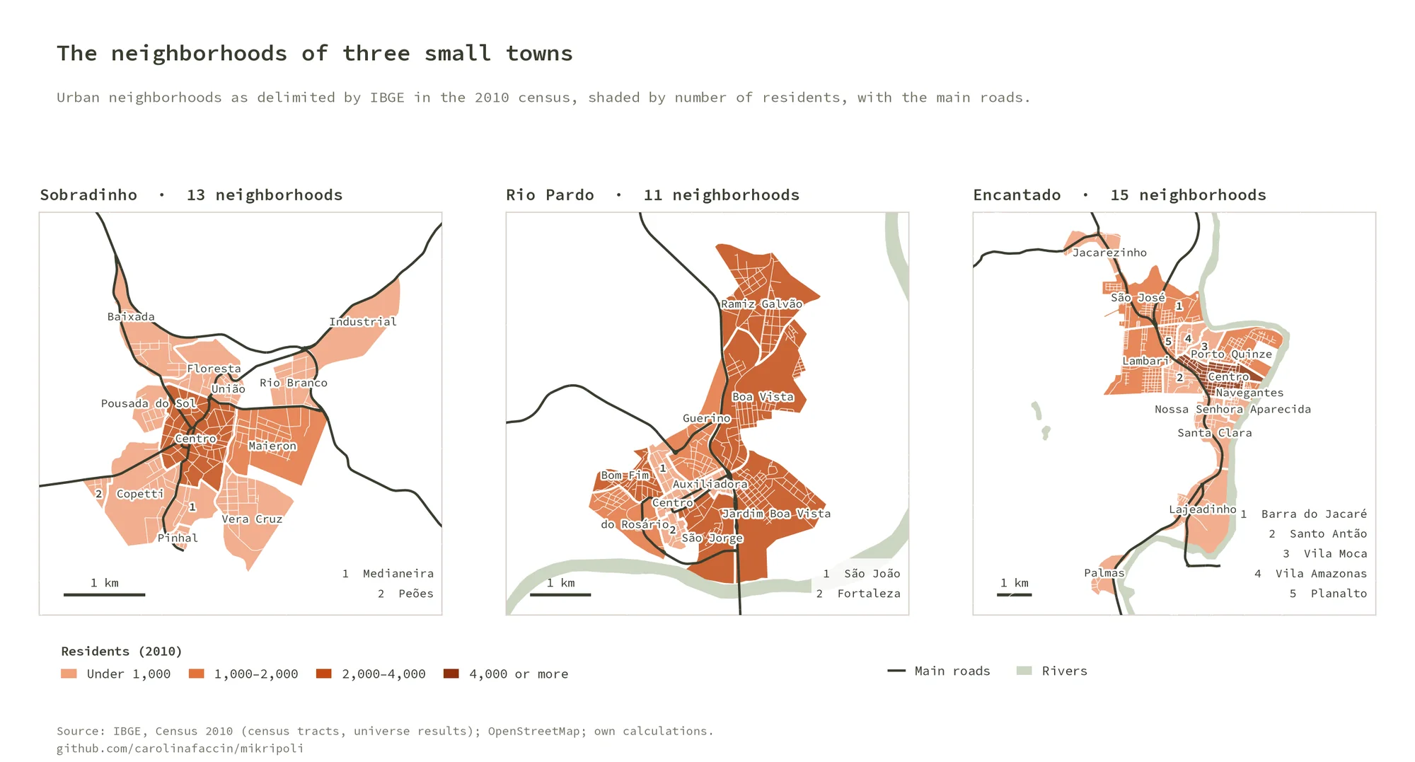
- A comparative morphology of Sobradinho (compact), Rio Pardo (dispersed growth, agricultural economy) and Encantado (fragmented expansion, diversified economy), with a clear center–periphery inequality in all three.
- In 2024–2025, the same team analyzed the impacts of the floods on small cities.
Why it matters#
The work provides a baseline for planning in places that usually lack one, and brings small cities into debates on regional development and climate adaptation.
I later rebuilt the census maps of the three towns as an open, reproducible Python pipeline: code and figures on GitHub.
Publications:
- Detoni, Faccin, Silveira, Rorato & Machado (2025) (EN): extreme climate events and their sociospatial impacts on small cities.
- Silveira, Faccin & Detoni (2023) (EN): small cities and changes in the regional urban network.
- Silveira, Faccin, Detoni & Silva (2024) (PT): comparative morphology of three small cities.
- Silveira, Faccin, Detoni, Menezes & Haas (2022) (PT): a typology of small cities in the Vales Region.
- Rorato, Detoni & Faccin (2022) (PT): teaching small cities in a GIS course at UFRGS.
- Detoni, Faccin & Rorato (2023) (PT): the “Architectures of a Small City” collage workshop.
Figures#
The census and neighborhood maps are produced by the open pipeline above.